
A new study focused on the 6.8 M Luding earthquake in China’s Sichuan-Yunnan seismic zone, shows how dams make areas susceptible to earthquakes directly (through RIS) and indirectly by altering geological structures, causing earthquakes, which, in turn, cause other earthquakes.
By Fan Xiao
Fan Xiao, a Chinese geologist and environmentalist, is the retired Chief Engineer of the Regional Geological Survey Team of the Sichuan Geology and Mineral Bureau and a member of the Sichuan Seismological Society.
Originally posted October 8, 2022 on the WeChat account “HeShanWuYan” (Rivers and Mountains in Silence; 河山无言)
The 6.8 M Luding earthquake in September shows strong seismic activity in western Sichuan has been aggravated, not eased.
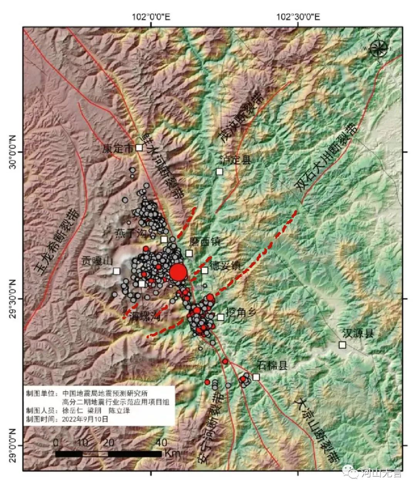
Following several strong and moderately strong earthquakes in Hanyuan, Lushan and Maerkang in Sichuan from May to June 2022 respectively, the seismic zone in western Sichuan has not yet subsided as stronger activity has been observed. According to the China Earthquake Network, on September 5, 2022 at 12:52:18 p.m. local time, a 6.8-magnitude earthquake occurred in Luding County, Sichuan Province, with the epicenter coordinates of 29.59N, 102.08E and a depth of 16 km. The epicenter was located on the right bank of the Dadu River, between the Hailuogou Creek, a tributary of the Moxi River, and the Wandong River, a tributary of the Dadu River, a border area of Moxi Town and Detuo Township in Luding County, Ganzi Tibetan Autonomous Prefecture, Sichuan Province.

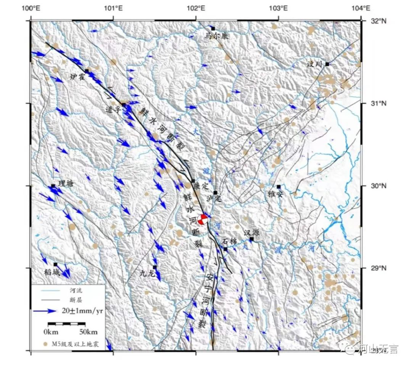
The location of the epicenter of the 6.8 M Luding earthquake (shown by the red five star in the map).
After the 6.8 M earthquake, a total of 2,715 aftershocks were recorded as of 08:00 on September 12, 2022, with 20 aftershocks of magnitude ≥2.8, the largest aftershock being 4.5.
The 6.8 M Luding earthquake sequence and subsequent 20 aftershocks
| Magnitude | Time of Occurrence | Latitude | Longitude | Depth (Km) | Location in Sichuan Province |
| 3.3 | 15:12:02 09-08-2022 | 29.78 | 102.01 | 10 | Luding County |
| 2.9 | 22:46:22 09-07-2022 | 29.67 | 102.06 | 10 | Luding County |
| 3.1 | 09:46:21 09-07-2022 | 29.42 | 102.16 | 9 | Shimian County |
| 3.0 | 08:34:35 09-07-2022 | 29.50 | 102.20 | 12 | Luding County |
| 3.3 | 05:39:56 09-07-2022 | 29.80 | 101.99 | 8 | Luding County |
| 4.5 | 02:42:15 09-07-2022 | 29.42 | 102.16 | 11 | Shimian County |
| 3.2 | 17:54:47 09-06-2022 | 29.61 | 102.01 | 8 | Luding County |
| 3.1 | 05:28:41 09-06-2022 | 29.64 | 102.07 | 11 | Luding County |
| 3.0 | 05:15:15 09-06-2022 | 29.42 | 102.15 | 9 | Shimian County |
| 3.1 | 01:24:36 09-06-2022 | 29.39 | 102.17 | 16 | Shimian County |
| 3.0 | 21:00:16 09-05-2022 | 29.39 | 102.16 | 15 | Shimian County |
| 3.6 | 19:26:20 09-05-2022 | 29.48 | 102.18 | 15 | Luding County |
| 3.0 | 18:31:19 09-05-2022 | 29.43 | 102.14 | 11 | Shimian County |
| 3.6 | 17:39:21 09-05-2022 | 29.37 | 102.17 | 17 | Shimian County |
| 3.2 | 03:28:46 09-05-2022 | 29.58 | 102.06 | 12 | Luding County |
| 2.9 | 13:28:23 09-05-2022 | 29.49 | 102.17 | 10 | Shimian County |
| 2.8 | 13:15:31 09-05-2022 | 29.51 | 102.11 | 8 | Luding County |
| 2.9 | 13:10:24 09-05-2022 | 29.46 | 102.14 | 10 | Shimian County |
| 3.1 | 13:03:14 09-05-2022 | 29.61 | 102.04 | 9 | Luding County |
| 4.2 | 12:56:34 09-05-2022 | 29.40 | 102.17 | 15 | Shimian County |
| 6.8 | 12:52:18 09-05-2022 | 29.59 | 102.08 | 16 | Luding County |
The aftershocks of magnitude <2.8 M not included in the above table.
Why was the damage caused by the 6.8 M Luding earthquake so extensive?
After the 2008 Wenchuan earthquake, several strong earthquakes have occurred in Sichuan. The 6.8 M Luding earthquake was not the largest, but it created more damage and casualties than the 7 M earthquake that occurred in Jiuzhaigou in 2017 and second only to the 7 M earthquake that occurred in Lushan in 2013.
According to the bulletin issued by the provincial, prefectural and county joint operational headquarters, as of 17:00 on September 11, 2022, a total of 93 people were killed in the 6.8 M Luding earthquake, including 55 people in Ganzi Prefecture, 38 people in Ya’an City; with 25 people still missing, including 9 people in Luding County, 16 people in Shimian County; with 423 wounded and treated in hospitals, including 6 people critically injured, and 42 people seriously injured. When the earthquake occurred, Sichuan launched a provincial earthquake emergency response Level 2 [i]. But as the death toll increased, the provincial earthquake emergency response was upgraded to Level 1 in the evening of September 5.
Based on the official website of Sichuan Provincial Government, more than 110,000 people were affected and more than 50,000 houses were damaged by the earthquake. A number of highways and local roads were blocked due to mountain collapses and landslides caused by the earthquake, including the Ya-Ye high-speed, 318 national highway, 108 national highway, 211 provincial highway, 217 provincial highway, as well as other local and rural roads. Moreover, the communication network was also affected, with 55 kilometers of fiber optic cable damaged, the service of 289 mobile phone base stations interrupted, and the communication service for more than 35,000 households affected. In terms of power supply, the line tripped and the substations were damaged and some of them even shut down, causing 43,158 users to lose power.
According to the statistics, 81.4% of the deaths and missing persons caused by this earthquake were due to mountain collapses, landslides and rolling rocks, and 18.6% were due to house collapses. The reason why the earthquake triggered a large number of mountain collapses and landslides, resulting in serious casualties, was also related to the topography of this area.
The quake zone is located on the eastern slope of the Minya Konka (Mount Gongga), with a height of 7,556 meters above sea level, which is the main peak of the Daxue Mountain of the Hengduan Mountain Range. The quake zone is also an alpine canyon area, which is not only the transition from the Tibetan Plateau to the Sichuan Basin, but one of the largest terrain contrasts on the Earth’s land surface. The lowest part of the Dadu River valley is only about 1,000 meters above sea level, and the relative height difference with Minya Konka is more than 6,400 meters, while the linear distance is only about 26 kilometers. Due to the extremely steep terrain, it has traditionally been a disaster-prone area for mountain collapses, landslides, and mudslides, etc. Coupled with the effects of the 2008 Wenchuan earthquake, and the subsequent Lushan, Kangding, Hanyuan, and Maerkang earthquakes, the vulnerability of the mountains in this region has increased greatly, making this 6.8 M Luding earthquake the cause of serious mountain collapses, landslides, and other geological disasters.
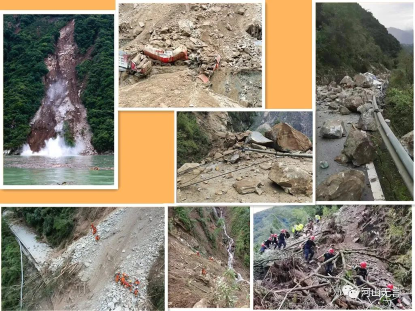
Geological disasters such as mountain collapses and landslides triggered by the 6.8 M Luding earthquake. (Source: the Internet.)

A landslide swarm triggered by the 6.8 M Luding earthquake along the Dadu River and its tributary, the Wandong River. (Source: The Earthquake Prediction Institute of the China Earthquake Administration.)
According to the Ministry of Emergency Management, the highest seismic intensity of the 6.8 M Luding earthquake was IX [ii], and the area of seismic intensity IX zone was about 280 square kilometers, including four towns such as Moxi Town, Detuo Town, Yanzigou Town and Dewei Town in Luding County of Ganzi Tibetan Autonomous Prefecture, and three townships such as Xinmin Tibetan and Yi Township, Wanggangping Yi and Tibetan Township and Caoke Tibetan Township in Shimian County of Ya’an City.
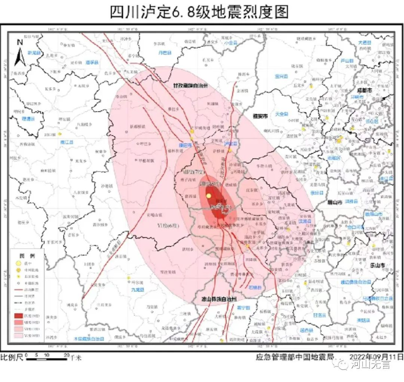
The seismic intensity map of the 6.8 M Luding earthquake. (Source: The Ministry of Emergency Management and China Earthquake Administration.)
Although the magnitude of the 6.8 M Luding earthquake was not as large as the 7 M Lushan earthquake in 2013 or the 7 M Jiuzhaigou earthquake in 2017, its highest seismic intensity reached IX, the same as the Lushan and Jiuzhaigou quakes which occurred in 2013 and 2017 respectively. Moreover, the total area with a seismic intensity of IX in the case of the 6.8 M Luding earthquake was greatest at 280 square kilometers, compared to 208 square kilometers of the 7 M Lushan earthquake, and 139 square kilometers of the 7 M Jiuzhaigou earthquake.
The large extent of the IX seismic intensity zone and the severe damage to buildings brought about by the Luding earthquake were also related to the topography of this area. Villages built on mountain slopes are vulnerable to mountain collapses and landslides. Moreover, most of the terraces and tablelands in this area, where village and town settlements are concentrated, have high and steep slopes, and strong earthquakes are likely to cause slope collapses, surface crack and sinking of terraces and tablelands, causing damage to buildings. In addition, the active fault that triggers the earthquake often extends along the river valley where the villages and towns are concentrated, which also has a more profound impact on building damage and economic loss.
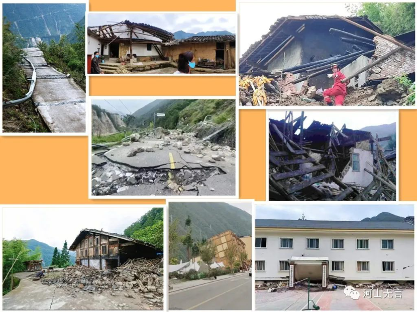

Building damage caused by the 6.8 M Luding earthquake. (Photos from the Internet.)
According to the news provided by the provincial earthquake emergency service center, the points of potential geological hazards in Luding and Shimian counties were numerous and widely distributed, with 480 registered before this earthquake. After the earthquake, as of September 7, when the first round of emergency investigation completed, the deformation of part of the original geological hazard spots intensified, and 169 new spots were identified.

The 6.8 M Luding earthquake caused the collapse of the side slope of the Moxi Platform, and the road and houses were damaged. The picture showed that the road was under emergency repair after the earthquake. (Image credit to Yang Shu, reporter for the “Sichuan Daily”).

The Moxi Platform extends in a long snake-like pattern along the Moxi River. The 6.8 M Luding earthquake created a mountain collapse and landslide swarm at the perimeter of the platform. (Source: The Earthquake Prediction Institute of the China Earthquake Administration.)
One of the dramatic secondary disasters caused by the earthquake was the barrier lake on the Wandong River, a tributary of the Dadu River. On September 5 around 19:15, the Water Resources Bureau of Ganzi Prefecture reported that the Wandong River had been interrupted for more than 6 hours. In the evening of that day, the Water Resources Department of Sichuan Province issued an emergency notice to alert the people in the downstream region who were in danger to get ready to evacuate.
It was later found that about one thousand people from Wandong and Ziyachang villages were trapped by the barrier lake, where a creek joins the Wandong River on the left bank. Fortunately, the Wandong River is not large with a length of 26.98 kilometers and the watershed area of 166.08 square kilometers, and its average multi-year flow is only 5.56 cubic meters per second at the mouth of the river. Based on the perennial flow and the river interruption of a total of about 16 hours, the water stored in the barrier lake was estimated about 600,000 cubic meters, so the water volume of the barrier lake was smaller than expected. In the early morning of September 6, the water of the barrier lake spilled over the dam and released naturally, with a maximum flow of 150-200 cubic meters per second, and the water entered the downstream] Dagangshan Reservoir on the mainstream of the Dadu River. After nearly 12 hours of discharge, the flow dropped to 10-15 cubic meters per second, so the risk of collapse of the barrier lake was basically eliminated.

Screenshot of an aerial image of the upstream of the barrier lake on the Wandong River. (Image credit: Sichuan Forest Fire Corps.)
The geological background of the 6.8 M Luding earthquake
The seismic rupture of the 6.8 M Luding earthquake was on the famous Xianshuihe Fault Zone, which was named after the Xianshui River, a tributary of the Yalong River. With a length of more than 350 km, the northwest-southeast Xianshuihe Fault Zone is one of the most active fault belts of the Sichuan-Yunnan “Y” shaped fault system. It is one of the two branches of the northern section of the Sichuan-Yunnan “Y” shaped fault system, which extends to the northwest along the line of Ganzi, Shiqu and Yushu. To the southeast, it turns to a nearly north-south direction near Kangding , and transitions to the north-south Anninghe Fault Zone south of Shimian, then links to the Zemuhe Fault Zone and the Xiaojiang Fault Zone to the south. As seen from the map below, this northwest then nearly north-south long fault belt stretches as far as Yushu in Qinghai Province in the northwest, and extends to the vicinity of Tonghai and Jianshui in Yunnan Province in the south.
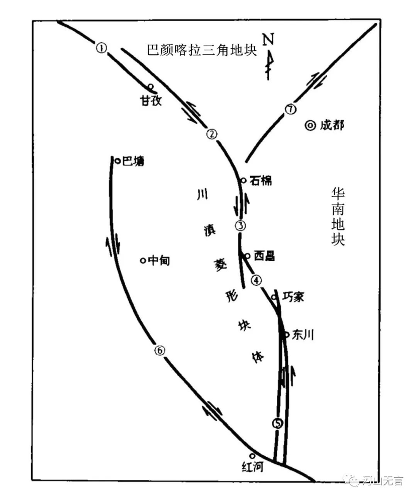
Sichuan-Yunnan regional fault tectonic framework (Pan Mao et al., 1994) ① Ganzi-Yushu Section of the Xianshuihe Fault Zone; ② Luhuo-Kanding-Shimian Section of the Xianshuihe Fault Zone; ③ Anninghe Fault Zone ④ Zemuhe Fault Zone ⑤ Xiaojiang Fault Zone ⑥ Honghe-Jinsha Fault Zone ⑦ Longmenshan Fault Zone.
The Xianshuihe Fault Zone is a well-known belt of strong seismic activity in western China, with a history of frequent earthquakes of magnitude >6 and even >7. Its main mode of activity is a counterclockwise (leftward) strike-slip along the steeply standing rupture surface, and the rupture activity of the 6.8 M Luding earthquake was no exception. The activity of the Xianshuihe Fault Zone was mainly caused by the extrusion and sliding eastward after the Qinghai-Tibetan block suffered from north-south extrusion. Some studies have shown that in the last 10,000 years since the beginning of the Holocene, the average sliding rate of some sections of the Xianshuihe Fault Zone can reach about 15 mm per year. The 15 mm per year may seem insignificant, but when viewed on a time scale of geological time or 10,000 years, the variation is huge.
The strong activity of the Xianshuihe Fault Zone since the Late Cenozoic Era (two or three million years ago) has left a very clear mark on the geomorphology along the fault zone, with water systems, valleys, terraces and moraine bodies breaking off, forming more than a dozen fractured basins that are distributed like strings of beads with many watershed plateaus uplifted between these basins. Such fractured basins and valleys can be seen from Kangding to the south along the Yajiageng Pass, Moxi River and Dadu River, which was also the geomorphological result of long-term activities of the Xianshuihe Fault Zone. In fact, the epicenter of the 6.8 M Luding earthquake was located in the north-south section from Kangding to Shimian of the southern extension of the Xianshuihe Fault Zone.
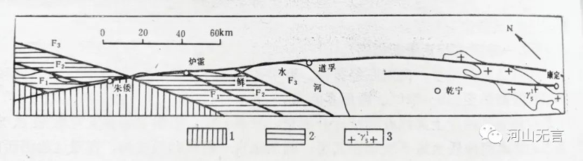
The geological bodies on both sides of the Zhuwo-Kangding section of the Xianshuihe Fault Zone have been misshifted leftward. The Triassic strata and early faults in the Zhuwo-Luhou section were misshifted by more than 40 km; the Triassic strata in the Luhou-Daofu section were misshifted by more than 20 km; the granite body in the Zoduo Mountain was misshifted by about 15 km. According to isotope dating, the Xianshuihe Fault Zone has been active since at least the Late Miocene, about 8 million years ago. Drawing above by Fan Xiao (Data source: Yao Dongsheng et al., 1988).
The glacial lateral moraine dikes of the Late Quaternary Pleistocene at the southern margin of the Degezhuqing Basin were counterclockwise staggered by the Xianshuihe Fault and displaced by tens of meters. Drawing above by Fan Xiao (Data source: Yao Dongsheng et al., 1988).
According to a briefing released by the Earthquake Prediction Institute of the China Earthquake Administration, the seismic fault of the 6.8 M Luding earthquake struck at 160° (south-south-east direction), with the fault tilted westward at an inclination of about 80. The initial rupture of the earthquake occurred at a depth of about 12.8 km below Hailuogou, expanding to both sides along the rupture. The whole rupture process lasted about 18 seconds, and after about 7 seconds the rupture turned to develop mainly in the southeast direction, with a total rupture length of 40 km (south of Yanzigou to north of Xinmin). The rupture direction was basically parallel to the Xianshuihe Fault Zone, and the maximum sliding amount reached 1.84 meters (about 13 km below Hailuogou).
This earthquake rupture was dominated by strike-slip motion, but a more obvious recoil motion occurred directly above the starting rupture point and 6-10 km below the subsurface south of Wandong Village. This may indicate that in the section where the Xianshuihe Fault Zone turns from north-west to nearly north-south, the impedance from the eastern land masses made the characteristic of the western land masses draping upward more obvious.

The regional tectonic map of the 6.8 M Luding earthquake. The red round dot shows the location of the initial rupture area (also the epicenter) of the earthquake. (Source: The Earthquake Prediction Institute of China Earthquake Administration).
The distribution of aftershocks of the 6.8 M Luding earthquake on September 5, 2022. (Source: The Earthquake Prediction Institute of the China Earthquake Administration.)
In addition to the ruptures along the north-west Xianshuihe Fault Zone (the ruptures were concentrated on the west side of the fault, or the upper plate), there were also ruptures along the southwest tail of the north-east Longmenshan Fault Zone (shown by the red dashed line in the image above. The Shuangshi-Dachuan Fault shown is the southern extension of the Longmenshan Frontal Fault Zone, and illustrates the complexity of the rupture at the meeting point of the fault belts.
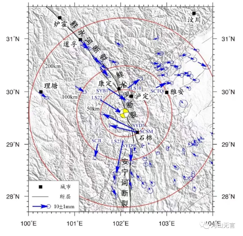
The isoseismic deformation field of the 6.8 M Luding earthquake based on GNSS measurements. This figure shows that there was a significant oblique movement of the fault in the main rupture section near the epicenter. (Source: The Earthquake Prediction Institute of the China Earthquake Administration).
Results from several other units, including the Institute of Geophysics of the China Earthquake Administration, indicated that the rupture of this earthquake along the Xianshuihe Fault Zone was dominated by ruptures that extended to the southeast. The isoseismic deformation measurements also indicated that the station about 40 km southeast of the epicenter had the largest isoseismic deformation of about 18 mm.
The Sichuan-Yunnan “Y”-shaped fault system divides the nearby land masses into three parts: the Bayankala triangle to the north, the Sichuan-Yunnan rhombus block to the west, and the South China block to the east. Compared to the Bayanqala triangle and the more stable South China block, the Sichuan-Yunnan rhombus block on the southwest side of the Xianshuihe Fault Zone is more active and has a greater speed of movement. This is the effect of the Sichuan-Yunnan rhombus being squeezed out to the east, forming a counterclockwise dislocation along the Xianshuihe Fault Zone. The Luding earthquake actually occurred at the boundary of the sudden change in velocity of the eastern edge of the Sichuan-Yunnan rhombus block.
The velocity field of land mass displacement on both sides of the Xianshuihe Fault Zone calculated from GNSS measurements before the 6.8 M Luding earthquake. The map showed that the land mass on the west side of the Xianshuihe Fault Zone had a greater velocity of movement in the southeast direction. (Source: The Earthquake Prediction Institute of the China Earthquake Administration).
Where are strong earthquakes likely to occur in the Sichuan-Yunnan region in the future?
The Xianshuihe Fault Zone, where the 6.8 M Luding earthquake occurred, and the Anninghe and Xiaojiang fault belts to the south, are the most seismically active fault zones in the Sichuan-Yunnan region. Like many other fault zones on earth, it is not a single fault belt that goes through (although it is often summarized by a single fault line on geological maps), but many fault belts are distributed just like a row of geese flying in a V. This diagonal arrangement is also known as a geese lineup. Therefore, the seismic activity of the entire fault zone showed a distribution pattern in which earthquakes were concentrated in clusters, with earthquakes in between being relatively rare. In addition, along the entire fault zone, earthquakes also showed a feature of back-and-forth migration.

Distribution of major fault zones and epicenters of strong earthquakes in Sichuan and Yunnan (Lin, Banghui et al., 1986).

Distribution of strong seismic tectonic areas of the Xianshuihe-Xiaojiang Fault Zone ( Zhang Shimin et al., 2001).
The epicenter of the 6.8 M Luding earthquake was located in the Kangding-Shimian strong earthquake activity zone in the southern section of the Xianshuihe Fault Zone. The recent strong earthquakes of magnitude ≥ 7 in the history of this section were: the 7 M Kangding (Selaha, northwest of Mugecuo) earthquake occurred in 1725; the 7.75 M Kangding (Yajiageng) earthquake in 1786; and the 7.5 M Kangding (Zeduotang) earthquake in 1955. Among them, the epicenter of the 7.75 M earthquake in 1786 was closest to the epicenter of the 6.8 M Luding earthquake.
The 7.75 M Kangding earthquake in 1786 was also a famous earthquake in the history of Sichuan. The seismic intensity of the epicenter area was ≥ Ⅹ and caused a massive landslide in the area of Mogangling on the right bank of the Dadu River near the present-day Detuo Township in Luding County. The huge landslide blocked the Dadu River forming a barrier lake that stretched up the river for more than 100 kilometers. Nine days after the interruption of the Dadu River, the barrier lake collapsed. The head of the ensuing flood was about ten feet high, and the situation was like a mountain collapse. The municipalities and towns along the Dadu River below the barrier lake were “washed away”. When the flood reached Jiading (now Leshan City), the head of the waves was still several feet high. The high waves dashed against the old southwest city wall of Jiading and hundreds of feet of the city wall washed away. The flood water from the Dadu River rushed into the Min River, pushing the water upstream approximately 5 kilometers along the Min River [iii]. Thousands of people drifted and struggled in the flood waters along the lower reaches of the Dadu and Min rivers, with many of them drowning.

The site of the massive landslide caused by the 7.75 M Kangding earthquake in 1786, which blocked the Dadu River and formed a barrier lake near Detuo Township in Luding County. The Dadu River interrupted for 9 days and caused huge floods in the downstream area after the barrier lake collapsed. The left side of the picture is the mouth of the Moxi River, where it merges into the Dadu River. (The base map is from Google Earth).
After a strong earthquake occurs, people often ask where will the next strong earthquake occur? In my earlier article (see here),”Talking about the recent earthquakes in Hanyuan, Lushan and Maerkang,” published on June 23, 2022, I pointed out that the northern edge of the Bayan Har block and the northern two branches of the Y-shaped fault system have experienced frequent earthquakes of magnitude ≥7 in the last decade or so, but the Xianshuihe, Anninghe, Zemuhe and Xiaojiang fault belts south of Luding have been free of earthquakes of magnitude ≥ 6 for more than 37 years, and the southern section of the Y-shaped fault system has been free of earthquakes of magnitude ≥ 7 for more than 52 years. Historically, strong earthquakes of magnitude ≥7 or even 8 have been frequent in this latter section. Therefore, the risk of future earthquakes in this southern section of the Y-shaped fault system deserves high concern.
Compared to previous strong earthquakes, which mainly occurred in the northern section of the Y-shaped fault system, the 6.8 M Luding earthquake suggests a tendency for strong earthquakes to migrate southward. The Earthquake Prediction Institute of the China Earthquake Administration calculated the triggering effect of Coulomb stress (force acting on a fault) caused by the 6.8 M Luding earthquake in 2022 on the southern section of the Xianshuihe Fault Zone, the Daliangshan Fault Zone, the Anninghe Fault Zone, and the southern section of the Longmenshan Fault Zone. The results showed that the Coulomb stresses caused by the 6.8 M Luding earthquake on the southern section of the Xianshuihe Fault Zone and the northern end of the Anninghe Fault Zone exceeded the triggering threshold, but the Coulomb stresses caused by the 6.8 M Luding earthquake on the southern section of the Longmenshan Fault Zone and the northern section of the Daliangshan Fault Zone did not reach the triggering threshold.
Despite the fact that magnitude ≥ 7 earthquakes have not occurred for several decades in the southern section of the Xianshuihe Fault Zone, the Anninghe Fault Zone, and the Xiaojiang Fault Zone, the 6.8 M Luding earthquake suggests a tendency now for strong earthquakes to to occur in the south. So, it is worthwhile paying attention to this region as a location of future strong earthquakes.
Was the 6.8 M Luding earthquake related to the cascade of high dams and large reservoirs on the mainstream of the Dadu River?
In the past decade or so, a cascade of high dams and large reservoirs have been built on the mainstream of the Dadu River for hydropower development, and whether they played a role in inducing earthquakes has become a matter of great concern. As a whole, a total of 27 power stations have been planned on the mainstream of the Dadu River, six have been completed and one is currently under construction on a 230 km long river section between Danba to Shimian on the mainstream of the Dadu River, which runs parallel with the southern part of the Xianshuihe Fault Zone. The seven dams are listed in the table below.
| Name | Dam Height (Meters) | Storage Capacity (Million Cubic Meters) | Installed Capacity (MW) | Status of Construction |
| Houziyan | 223.5 | 6.62 | 1,700 | Completed |
| Changheba | 240 | 10.15 | 2,600 | Completed |
| Huangjinping | 95.5 | 1.28 | 850 | Completed |
| Luding | 85.5 | 2.20 | 920 | Completed |
| Yingliangbao | 38 | 0.21 | 1,116 | Under Construction |
| Dagangshan | 210 | 7.42 | 2,600 | Completed |
| Longtoushi | 72.5 | 1.20 | 700 | Completed |
Among the seven dams listed in the above table, the Dagangshan Dam is considered the one with the highest risk of inducing strong earthquakes. As it happens, it is not only the one closest to the epicenter of the 6.8 M Luding earthquake, but its reservoir area overlaps with the Xianshuihe Fault Zone and other fault zones. Because of its high risk, a dedicated seismic monitoring network was set up in the reservoir area and the seismic activity had been monitored since 2013, before impoundment of the dam project began.
The construction of the Dagangshan Dam began in April 2009. It was put into operation at the end of 2015. The water level was 975 meters (above sea level) before impoundment. The first phase of the reservoir impoundment started at the end of December 2014, when the water level rose to 1,015 meters. The second phase began on May 29, 2015, when the water level increased by 105 meters within 36 days and rose to 1,120 meters (above sea level) by July 4. After September 2015, the water level reached the normal pool level of 1,130 meters.
The Dagangshan Reservoir is in an area where strong earthquakes have been frequent in history. A number of fault belts not only pass through the reservoir area, but some of them are connected to each other:
- The main fault of the southern section of the Xiangshuihe Fault Zone (the Moxi Fault) passes the west side of the reservoir along the line of Moxi-Wandong, and overlaps with the backwater area of Shiyue River and Tianwan River in the reservoir area;
- Another major fault of the Xiangshuihe Fault Zone, which is connected to the Longmenshan Fault Zone in the north – the Daduhe Fault (the Detuo Fault) – runs underneath the reservoir area along the Dadu River valley and intersects with the Moxi Fault near the Tianwan River area in the south;
- On the east side of the Daduhe Fault is the Yusaping-Wajiao Fault Zone which runs approximately north-south and passes near the Dagangshan Dam and intersects with the Xiangshuihe Fault Zone near Xinmin (Township) in the south.
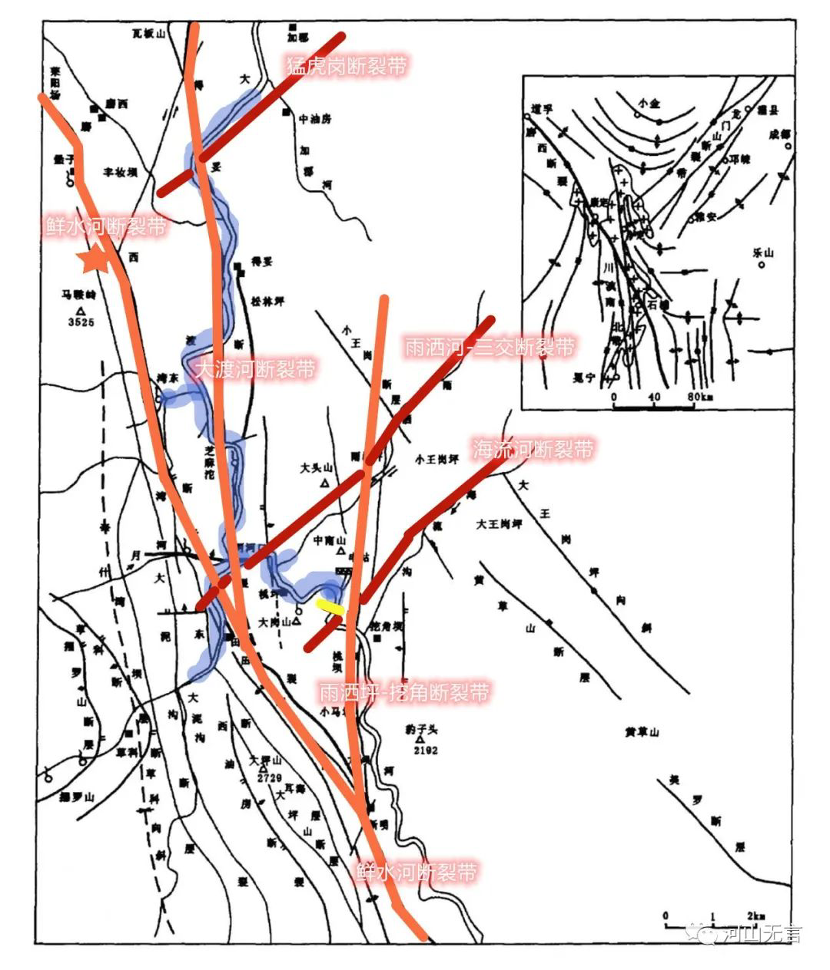
The regional tectonic sketch of the Dagangshan Reservoir, modified from the original map by Zhong Guohua (2004). The blue area is the reservoir area of the Dagangshan Dam, the short yellow line is the location of the Dagangshan Dam, and the red five star is the epicenter of the 6.8 M Luding earthquake.
In addition, there are a set of northeast faults nearby, which are less frequently mentioned, but they are well represented on the geomorphology and satellite images: near the Dagangshan Dam, they extend roughly along the Yusahe-Sanjiao and Hailiu River, controlling several nearly 90-degree fold-like turns of the Dadu River and Tianwan River in the Dagangshan Reservoir area. Historical earthquakes were also distributed along this fault. The Yusahe-Sanjiao Fault is intermittently connected with the southwest section of the Longmenshan Front Range Fault (Shuangshi-Dachuan Fault), which can be regarded as the southwest tail of the Longmenshan Front Range Fault, and it intersects with the Xianshuihe Fault and the Daduhe Fault in the area near the mouth of the Tianwan River. It is worth noting that this group of north-east faults plays a role of connecting the nearly north-south faults such as the Xianshuihe Fault, Daduhe Fault and Yusaping-Wajiao Fault, which may have an significant impact on the infiltration of reservoir water along the main fault of the Xianshuihe Fault Zone.
Based on the above-mentioned engineering and geological background of the reservoir area, seismologists believe that the Dagangshan Reservoir has the potential to induce moderate and strong earthquakes (Du Yao et al., 2016).
Du Yao et al. (2016) analyzed the background of seismic activity in the Dagangshan Reservoir area before the impoundment of the reservoir. By analyzing the data of 4,263 seismic events from 28 stations in the reservoir area, including Dagangshan, Luding and Pubugou and others, during a period between March 2013 to December 2014 (before impoundment), Du Yao et al. found that earthquakes were mainly concentrated in four areas (see the figure below):
- Area A: on the northwest side of the reservoir area, and along the Moxi Fault Zone;
- Area B: on the west side of the reservoir area and west of the Moxi Fault Zone, which was also the most concentrated area of earthquakes, the Luding 6.8 M earthquake also occurred in this area;
- Area C: the main part of the reservoir area along the Dadu River valley, in which Moxi Fault Zone and Detuo Fault Zone run through it;
- Area D: on the northeast side of the reservoir area, and related to the southwest section of the north-east Longmenshan Fault Zone.

The distribution of earthquakes in the Dagangshan Reservoir area before impoundment (Du Yao et al., 2016).
It is worth noting that in addition to the general distribution of earthquakes along the Moxi Fault and the Detuo Fault, there was also a spreading along the north-east direction, reflecting the activity of the south end of the north-east Longmenshan Fault in this region.
For the earthquakes in this area before the impoundment of the Dagangshan Reservoir, the fault activity mode was mainly strike-slip, accounting for 49%; the retrograde type (rising upper plate) and positive fault type (falling upper plate) account for 20% and 19% respectively, and another 12% was undetermined. It indicated that the mode of fault activity triggering earthquakes was more complicated.
Zhu Jazheng et al. (2022) studied changes in the seismic activity in the Dagangshan Reservoir, after and before the impoundment, by comparing the seismic data from November 2014 to November 2017 with the data from November 2011 to November 2014. They found that after the impoundment (the dam started impounding on December 30, 2014), the earthquakes in the reservoir area generally showed the characteristics of clustering and enhancement. However, the seismicity on the west side of the Xianshuihe Fault Zone significantly increased, while the seismicity on the east side of the Daduhe Fault Zone slightly decreased.
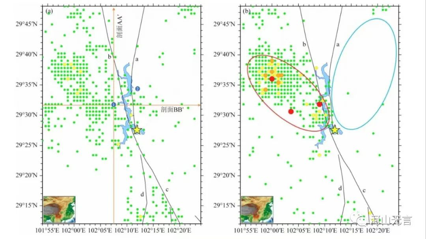
Changes in seismic activity in the Dagangshan Reservoir area before and after the impoundment (Zhu Jiazheng et al., 2022).
The left figure (a) showed the distribution of earthquakes in the reservoir area from November 2011 to November 2014 (before the impoundment). The right figure (b) showed the distribution of earthquakes in the reservoir area from November 2014 to November 2017 (after impoundment). The yellow five-star indicates the location of the Dagangshan Dam. The black lines are the major faults through the reservoir area. The circles of different colors represent the epicenters: the green circle presents 0-2 M earthquakes, yellow circle >2-3 M earthquakes, orange circle >3-4 M earthquakes, and red circles >4 M. The red oval circle is the area where seismic activity increased after the impoundment, and the blue oval circle is the area where seismic activity decreased after the impoundment.
According to Zhu et al. (2022), the main area of the impoundment in the Dagangshan Reservoir area was located in the lower plate of the Xianshuihe Fault Zone or the upper plate of the Daduhe Fault Zone [iv]. The loading effect of the reservoir impoundment caused the Xianshuihe Fault Zone to become more active and suppressed the activity of the Daduhe Fault Zone.
Numerical model calculations showed that under the superimposed influence of the gravitational effect of reservoir water and the increase in pore pressure caused by water seepage along the fault zone, the amount of the Coulomb stress change west of the Xianshuihe Fault Zone is positive, with a maximum increase of 45 kPa [v]. The amount of Coulomb stress change east of the Daduhe Fault Zone is negative, with a maximum decrease of about -12 kPa. However, further calculations showed that when the reservoir impoundment was maintained at the normal pool level, the increase in pore pressure caused by seepage along the fault zones as the impoundment time continues to increase would cause the amount of coulomb stress change in the entire reservoir area to tend to positive values, leading to an overall increase in seismic activity in the area (Zhu Jiazheng et al., 2022).

Changes in Coulomb stress and pore pressure in the region of the seismic activity enhanced (figure (a) on the left) and the seismic activity weakened (figure (b) on the right) in the Dagangshan Reservoir area (Zhu Jiazheng et al., 2022).
The coordinates on the left side of the figure are the elevation of the water level, the coordinates on the right side of the figure are the Coulomb stress values, and the coordinates on the bottom of the figure are the time. The blue line of the curves indicate water level change, the purple line shows pore pressure change, the brown line indicates the amount of Coulomb stress change that includes pore pressure, and the green line shows the amount of Coulomb stress change that does not include pore pressure. We can see here that pore pressure, which has the greatest influence on the fault activity, and the Coulomb stress variation containing pore pressure, continue to increase as the time after the impoundment continues.
In addition, Zhuang Yuanxu et al. (2022) also pointed out that there was an increase of the seismic activity in the reservoir area after impoundment of the Dagangshan Dam, particularly during the period from 2015 to the end of 2017.
Although the above study did not include the seismic data for the reservoir area from December 2017 to September 5, 2022 or before the 6.8 M Luding earthquake, the results of the study have showed that there was indeed a possibility that the reservoir impoundment caused a continuous increase in the seismic activity in the reservoir area before the 6.8 M earthquake occurred in Luding County. Moreover, the epicenter of the 6.8 M Luding earthquake happened to be located on the west side of the Xianshuihe Fault Zone, where the increase of the seismic activity in the reservoir area was most obvious after the impoundment. Therefore, the possibility of a 6.8 magnitude earthquake in Luding induced by the impoundment in Dagangshan Reservoir cannot be ignored.
It should be noted that the 4.8 M earthquake that occurred in Hanyuan (County) on May 20, 2022, was located at the intersection of the north-east Yusahe-Sanjiao Fault and the north-west Hanyuan-Ganluo Fault on the east side of the Dagangshan Reservoir. So was the 4.8 M Hanyuan earthquake affected by the impounding activity in Dagangshan Reservoir as well? And the subsequent 6.1 M earthquake that occurred in Lushan (County) on June 1, 2022 was located on the Shuangshi-Dachuan Fault, which is the northern extension of the Yusahe-Sanjiao Fault. Was this earthquake triggered by the 4.8 M Hanyuan earthquake? Furthermore, was the 6.8 M Luding earthquake a chain reaction of stress conduction and release in the rendezvous area of fault zones? These questions should be answered and further studies are needed.
In addition, on the mainstream of the Dadu River upstream of the Dagangshan Dam, dozens of high dams and large reservoirs have either been completed, are under construction or are planned. The dams completed include Luding, Huangjinping, Changheba, and Houziyan. The dams under construction, or to be built, include Danba, Badi, Jinchuan, Shuangjiangkou, Busigou, Dawei, Bala, Xiaerjia and more. The impact of these cascades of high dams and large reservoirs on seismic activity in the northern section of the Sichuan-Yunnan Y-shaped fault system and the Bayan Har block, also requires more attention, research and improved monitoring.
_________________________________
[i] Earthquake emergency response Level 2: more than 10 people, less than 30 people dead and missing, or 6.0-6.9 M earthquake in densely populated areas, or 6.5-7.4 M earthquake in other areas; Level 1: more than 30 people dead and missing, or 7 M and greater earthquake in densely populated areas, or 7.5 M and greater earthquake in other areas.
[ii] Seismic intensity is a way of measuring or rating the effects of an earthquake at different sites – the degree of damage on the earth’s surface and to man-made structures, such as dams and buildings, for example. Intensity ratings are expressed as Roman numerals between I at the low end and XII at the high end. Signs of the building damage for seismic intensity IX: brick (earth and stone) wooden structure houses mostly destroyed and severely damaged; through type timber frame houses a few destroyed, most severely damaged and moderately damaged; fortified brick and concrete structure houses mostly severely damaged and moderately damaged, a few slightly damaged; unfortified brick and concrete structure houses a few destroyed and mostly seriously damaged and moderately damaged; most of the houses with reinforced concrete frame structure are seriously damaged, most of them are moderately damaged and slightly damaged.
[iii] The situation occurred near Leshan City of Sichuan Province, where the Dadu River merges into the Min River, which is the tributary of the Yangtze River.
[iv] Since both the Xianshuihe Fault Zone and the Daduhe Fault Zone are strike-slip fault, parallel to each other, and their fracture surfaces through the reservoir area are generally inclined to the west, the land located between the two fault zones is both the lower plate of the Xianshuihe Fault Zone and the upper plate of the Daduhe Fault Zone.
[v] 45 kPa equals to 0.45 bar, or 0.45 standard atmosphere at a depth of 5 km. Some studies have shown that an incremental change in Coulomb stress of as little as 10 kPa (0.1 bar) is sufficient to have a significant effect on seismic activity.
_________________________________
References
Lin Banghui, Chen Tianchang, Pu Xiaohong, et al. (1986), Rupture processes and seismic activity of strong earthquakes in the Xianshuihe Fault Zone, Journal of Seismology, 8(1): 1-20.
Yao Dongsheng and Fan Xiao (1988), Left-slip faults of the Late Cenozoic on the western Sichuan Plateau, Geomechanics, Beijing: Geological Press, Vol. 8, 53-61.
Pan Mao, Liang H., Cai Yongen et al. (1998), A comparative study of the geometry, kinematic characteristics and seismicity of the Xianshuihe Fault and Zemuhe Fault in western Sichuan, China, China Earthquake, 10(1): 28-37.
Zhang Shiming and Xie Furen (2001), Delineation of strong earthquake tectonic zones above 7-magnitude in the Xianshuihe-Xiaojiang Fault Zone and its tectonic-geomorphological characteristics, Journal of Earthquake, 23(1): 36-44.
Zhong Guohua (2004), Hydrogeological analysis of reservoir-induced earthquakes in Dagangshan Power Station, Master’s thesis, Chengdu University of Technology.
Du Yao, Zhang Zhiwei, Ruan Xiang et al (2016), Spatial distribution and stress field characteristics of earthquakes before the impoundment of the Dagangshan Reservoir, Journal of Earthquake Engineering, 38(Suppl. 1): 36-43.
Zhu Jiazheng and Sun Yujun (2022), Numerical simulation study of the effect of the impounding activities on seismic activity in Dagangshan Reservoir, Sichuan, Journal of Geophysics, 65(10): 3930-3943.
Zhaung Yuanxu, Ding Yong and Du Yao et al (2022), Study on 3D velocity imaging before and after the impoundment of the Dagangshan Reservoir, Science and Technology Innovation and Applications, (11): 1-18.
Institute of Earthquake Prediction of China Earthquake Administration (2022), General characteristics of synoptic landslides based on post-earthquake high-resolution (GF-6) satellite images.
Institute of Earthquake Prediction of China Earthquake Administration (2022), Analysis and output of isoseismic deformation field, pre-earthquake velocity field and theoretical isoseismic deformation field of the 6.8-magnitude earthquake in Luding, Sichuan.
Institute of Earthquake Prediction of China Earthquake Administration (2022), Latest results of GNSS isoseismic deformation field for the 6.8-magnitude earthquake in Luding, Sichuan.
Department of Science, Technology and International Cooperation of China Earthquake Administration (2022), Latest results on the rupture process of the 6.8-magnitude earthquake in Luding, Sichuan.
(Fan Xiao, a Chinese geologist and environmentalist, is the retired Chief Engineer of the Regional Geological Survey Team of the Sichuan Geology and Mineral Bureau and a member of the Sichuan Seismological Society.)


