
Two strong and separate earthquakes rattled northwest and southwest China this month – one of them the strongest since the devastating Wenchuan earthquake of 2008. The series of May quakes are part of the Himalayan-Mediterranean seismic belt, one of the largest seismic belts on earth. Chinese geologist and environmentalist, Fan Xiao, provides structural analysis of the events and examines the presence of hydropower activity in the region.
By Fan Xiao
Fan Xiao, a Chinese geologist and environmentalist, is the retired Chief Engineer of the Regional Geological Survey Team of the Sichuan Geology and Mineral Bureau and a member of the Sichuan Seismological Society.
A discussion on the geological background structure of the 6.4-magnitude earthquake in Yunnan and 7.4-magnitude earthquake in Qinghai on May 21 and 22, 2021.
On May 21, 2021 at 9:48:34 p.m. local time, a 6.4-magnitude earthquake occurred in Yangbi County, Yunnan Province, while on May 22, 2021 at 2:04:11 a.m. local time, a 7.4-magnitude earthquake occurred in Maduo County, Qinghai Province. The two separate earthquakes occurred less than 5 hours and less than 1,000 kilometers apart. More importantly, the 7.4 magnitude Maduo earthquake has been the strongest so far since the Wenchuan 8-magnitude earthquake occurred in 2008 in mainland China, so it caused a great deal of concern.
The earthquakes in the two places did not happen suddenly, but a corresponding earthquake sequence composed of foreshocks, main shocks, and aftershocks.
Prior to the 6.4 M earthquake in Yangbi, Yunnan Province, 13 earthquakes of magnitude ≥ 3 occurred within 54 kilometres of the epicenter of the 6.4 M earthquake since January 3, 2021. Among them, 10 earthquakes of magnitude ≥ 3 occurred from May 18 to May 20, before the 6.4 M earthquake occurred on May 21. After the main shock, 26 aftershocks of magnitude ≥3 had occurred as of May 22 at 9:48 a.m., with the largest aftershock being 5.2 M.

Before the 7.4 M earthquake occurred in Maduo County of Qinghai Province, a 4.2 M earthquake occurred on December 24, 2020 within 46 kilometres of the epicenter of the 7.4 M earthquake. Since no data on less than 3 M earthquakes is available, it is not ruled out that there were many foreshocks of less than magnitude 3 before the 7.4 M quake. After the main shock, 28 aftershocks of magnitude ≥3 had occurred as of May 22 at 3:06 p.m., with the largest aftershock being 5.1 M.
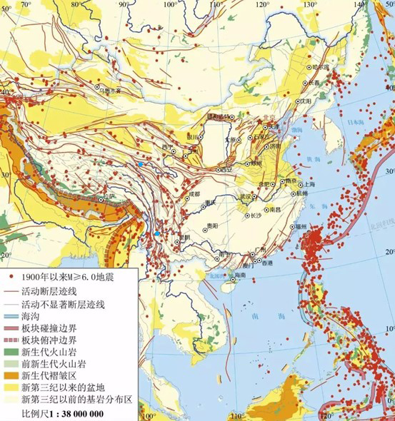
The two places, Yangbi in Yunnan (Province) and Maduo in Qinghai (Province) belong to different active fault zones and seismic zones. It cannot be judged that there is a direct structural connection between the two earthquakes, but they both belong to the geological tectonic unit and seismic activity in the eastern Qinghai-Tibet Plateau. From a larger perspective, they are all part of the Himalayan-Mediterranean seismic belt, one of the largest seismic belts on earth. The faults and seismic activity in this area is mainly related to the movement and dislocation of the Qinghai-Tibet block to the east and southeast after being squeezed from north to south.
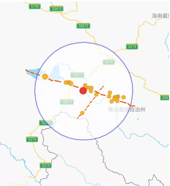
The 7.4 M Maduo earthquake in Qinghai is located on the East Kunlun Fault Zone. This fault zone is also called the Tosuo Lake-Maqu Fault Zone or the Kusai Lake-Maqu Fault Zone by different scholars. This fault zone has the characteristics of left-handed (counterclockwise) sliding in the horizontal direction, and the average annual sliding rate can reach 10 to 15 mm (according to Deng Qidong, 1996).
The records of strong earthquakes in this fault zone include the 7 M Xiugou-Arak Lake earthquake in 1902; and the 7.5 M Huashixia earthquake in January 1937. However, the 7.4 M earthquake this time didn’t occur on the main fault of the East Kunlun Fault Zone, but on a branch fault parallel to the south side of the East Kunlun Fault Zone. This branch fault extends from Zhaling Lake and the southern margin of Eling Lake to the Yellow River Valley near Huanghe Township in Maduo County of Qinghai Province.
The 6.4 M Yangbi earthquake, on the other hand, occurred on the Honghe Fault Zone. This is an active fault that separates the two major geological and geomorphological units of Yunnan (Province) from the east and the west. It extends southward into Vietnam and can be connected to the Jinshajiang Fault Zone to the north. The Honghe Fault Zone has the characteristics of sliding right-handed (clockwise) in the horizontal direction, and the average annual sliding rate can reach 7 to 8 mm (according to Deng Qidong, 1996).
The northern section of the main fault of the Honghe Fault Zone is generally considered to pass through the eastern side of the Cangshan Mountain and the Erhai Lake. However, the 6.4 M Yangbi earthquake did not occur on the main fault of the Honghe Fault Zone, and its epicenter is located on the branch fault parallel to the main fault of the Honghe Fault Zone on the west side of the Cangshan Mountain.
Moreover, the main fault of the Honghe Fault Zone weakens and dwindles north of the Erhai Lake, while the faults spreading along the Yangbi River valley at the foot of the western slope of Cangshan Mountain seems to be part of the more obvious Honghe Fault Zone and extending northward. Chang Zufeng et al. (2016) called it the “Weixi-Qiaohou-Weishan Fault”. The epicenter of the 6.4 M Yangbi earthquake is located on the west side of this fault, not in the Yangbi River valley, but near the Qingshuilang Mountain ridge on the west side of the valley.
A friend asked if the 6.4 M Yangbi earthquake was related to the reservoir impoundment activities of nearby hydropower projects. In terms of spatial location, the closest to the epicenter of the 6.4 M Yangbi earthquake is the cascade of reservoirs on the mainstream of the Lancang-Mekong River west of the epicenter. Several power stations within 100 kilometres of the epicenter in a straight-line distance are as follows (from upstream to downstream):
- The Huangdeng Hydropower Station, with a storage capacity of 1.418 billion cubic metres, a maximum dam height of 203 metres, and an installed capacity of 1.9 million kilowatts, started impounding in November 2017, and was complete and put into operation in January 2019;
- The Dahuaqiao Hydropower Station, with a storage capacity of 293 million cubic metres, a dam height of 106 metres, and an installed capacity of 920,000 kilowatts, started impounding in February 2018, and was completed and put into operation in January 2019;
- The Miaowei Hydropower Station, with a storage capacity of 660 million cubic metres, a maximum dam height of 131.3 metres, and an installed capacity of 1.4 million kilowatts, started impounding in 2015, and was completed and put into operation in 2017;
- The Gongguoqiao Hydropower Station, with a storage capacity of 316 million cubic metres, a dam height of 105 metres, and an installed capacity of 900,000 kilowatts, started impounding in October 2011, and was completed and put into operation in March 2012;
- The Xiaowan Hydropower Station has a storage capacity of 14.914 billion cubic metres, a dam height of 294.5 metres, and an installed capacity of 4.2 million kilowatts. The dam project started impounding in December 2008, and was completed and put into operation in August 2010.
From the perspective of storage capacity and dam height, Huangdeng, Miaowei, and Xiaowan are all hydropower reservoirs with a high probability of inducing earthquakes. However, there is no detailed data and related analysis of the seismic activity since the impoundment of these reservoirs, so it is not yet clear whether the Yangbi 6.4 M earthquake is related to these reservoirs.
In addition, in the Sichuan-Yunnan region, the Xiangjiaba and Xiluodu, two cascade hydropower stations on the Jinsha River mainstream, have produced obvious reservoir-induced earthquakes since they began impounding in 2012 and 2013 respectively. Among them, the Xiluodu Reservoir has triggered the largest magnitude quake as great as 5.3 M. The Jinping I Hydropower Station on the mainstream of the Yalong River has seen an explosive increase in earthquakes in the reservoir area since its impoundment in 2013. It once induced a cluster of moderately strong earthquakes with magnitudes ranging from 3.9 to 4.3 within just one day.
In the near future, moreover, special attention should be paid to two other giant hydropower stations, the Baihetan and the Wudongde dams, currently under construction on the mainstream of the Jinsha River, both of which will introduce risks of reservoir-induced earthquakes.
The Baihetan and Wudongde dam projects are huge: with a storage capacity of 20.6 billion and 7.6 billion cubic metres, a maximum dam height of 289 metres and 270 metres, and installed capacity of 16 million kilowatts and 10.2 million kilowatts respectively.
The Wudongde started impounding in January 2020 and is expected to be completed and put into operation in July 2021, while the Baihetan will start impounding in April 2021 and is expected to be completed and put into operation in 2022.
These two reservoirs are not only huge in scale, but also located on the highly active Xiaojiang Fault Zone, on which an 8 M earthquake occurred in history.
Therefore, it is necessary to pay close attention to the earthquake monitoring data of these two reservoir areas, and analyze and evaluate the materials in time.
To prevent and mitigate disasters in earthquake-prone areas in western China:
- All construction should be in in accordance with the national standard “Code for Seismic Design of Buildings”;
- Seismic intensity standards of buildings should be implemented;
- Those buildings which do not meet the standards should be strengthened;
- Improve the monitoring of landslides, mudslides and other potential geological disasters;
- New construction projects should avoid active fault zones and geological hazard dangerous areas;
- Implement emergency plans and practice in responding to earthquakes and other geological disasters in the reservoir and surrounding areas.


Very detailed, thanks for sharing this.