
Late last year, Mu Lan, the editor of Probe International’s Three Gorges Probe news service in Chinese, followed the central leg of China’s massive South-to-North Water Diversion Project with his camera as it made its way from Hubei Province to Beijing, the project’s ultimate destination.
The eastern route of China’s South-to-North Water Diversion Project began formal operation in December 2013. The project’s central canal route officially started flowing on December 12, 2014. From late November to early December 2014, Mu Lan, the editor of Probe International’s Three Gorges Probe news service in Chinese, set out to follow the route of the central leg as it made its way north to Beijing.
With a total length of 1,276 km, the central canal route represents an ultra long-distance water transfer project which begins at the Danjiangkou reservoir in Hubei, a province in central China that connects the country’s east and west, as well as the country’s north and south. From Hubei, the central route traverses the provinces of Henan (central China) and Hebei (northern China), before it arrives in Tuanchenghu near the Summer Palace in Beijing (northeastern China). According to the official plan, Beijing will receive 1.238 billion cubic meters of water from the country’s south annually by 2020, which represents about one-third of Beijing’s current water consumption.
From a technical point of view, the central route is a gigantic undertaking in terms of size, complexity and the number of people moved to make way for it. The project, conceived as a way to replenish China’s arid north by tapping the country’s resources south, has been a controversial one from the get-go. Proponents say the project will send water to the country’s thirsty north in general, and Beijing in particular, affording the capital great relief: hundreds of millions of people in the north will benefit from it, they say. Opponents argue that the cost of the project is huge: first of all, nobody knows the potential environmental risks operation of the central canal poses; secondly, at least 330,000 people were moved to make way for the project, many of whom were forced to do so in the 1950s when the Danjiangkou dam in Hubei Province was built; and thirdly, they say the project will negatively impact the middle and lower sections of the Han River below the Danjiangkou dam.
In a recent article published by China’s Green Leafs Magazine, run by the Ministry of Environmental Protection, Wang Jian, a Beijing-based water expert, raised eight concerns about the flow of water into Beijing from the south. His concerns include: the potential threat of floods, the safety of building a massive canal network over fault lines, the safety of building a massive canal in a densely populated urban area with complex underground infrastructures, the problem of groundwater pollution when the water table rises as a result of water flow from the south to Beijing, the issue of how much water is actually available to send to Beijing if both sending and receiving regions suffer drought at the same time, among other concerns. [An English translation of Wang Jian’s article will soon be available via Probe International].
Below are the photographs Mu Lan took (57 in total) as he followed the transfer project’s journey from Danjiangkou reservoir in Hubei to Beijing.
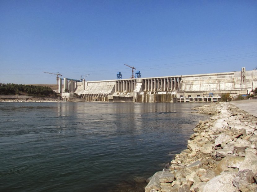
(1) The Danjiangkou reservoir in Hubei Province, where the 1,276-km central route of the South-to-North Water Diversion Project begins.

(2) Fields become flooded when the Danjiangkou reservoir raises its water levels.

(3) A highway partially flooded.

(4) Another view of the Danjiangkou reservoir and the starting point for the South-to-North Water Diversion Project’s central canal.

(5) A slightly different view: the water from the Danjiangkou reservoir flows north via the central canal.

(6) A fisherman tries his luck.

(7) Fishing boats at rest along the central canal.

(8) Fish are still alive and the water looks clear.

(9) The central canal’s headwork is located in Xichuan County, Henan Province. Headwork: any hydraulic structure which supplies water to an off-taking canal.

(10) The central canal’s headwork, upstream, facing the Danjiangkou reservoir.

(11) Water levels upstream of the headwork.

(12) A mobile laboratory, parked by the headwork, monitors water quality (operated by the Yangtze River Water Resources Protection Bureau).

(13) The headwork, downstream, to the north.

(14) Water level marks located downstream of the headwork.

(15) The revetment situated upstream of the headwork. Revetment: a facing of masonry, or the like, usually built to preserve the existing uses of the shoreline and to protect the slope, as a defense against erosion.

(16) The revetment situated on the north bank downstream of the headwork.

(17) The central canal’s first bridge.

(18) A bridge and a highway.

(19) This bridge is nearly completed, workers are busy adding the final touches. The sign above the bridge says: “Celebrating the opening of the central canal of the South-North Water Diversion Project”.

(20) The central canal’s water continuing its northward flow.

(21) A migrant village near the location of the central canal’s headwork in Jiuchong Town, Xichuan County, Henan Province. Locals were moved to make way for the headwork project.

(22) Housing in the migrant village.

(23) Newly opened vegetable plots in the village.

(24) A poster near the migrant village bearing a slogan that reads: “The success or failure (of the central canal project) relies on water quality, the key to success lies in resettlement, and the priority is to complete the project”.

(25) The central canal of the South-to-North Water Diversion Project in a suburb of Zhengzhou, the capital of Henan Province.

(26) A view of the central canal’s water levels.

(27) The banks of the central canal.

(28) A bridge over the central canal located in a suburb of Zhengzhou City.

(29) Construction equipment used to build the canal.

(30) The steep slopes of the central canal.

(31) The Yellow River tunnel project’s checkpoint (water pumped through a tunnel beneath the river feeds the central route of the South-to-North Water Diversion Project).

(32) Climbing is strictly prohibited.

(33) Littering is strictly prohibited.

(34) Diving is strictly prohibited.

(35) Water from the south flowing into the Yellow River is diverted through a tunnel that runs underneath.

(36) Bridges crossing over the central canal near to the Yellow River tunnel project.

(37) The Yellow River tunnel project.

(38) Anyang City, in Henan Province, where the central canal passes.

(39) A bridge that crosses the central canal in northwest Anyang City.

(40) The central canal near Anyang City.

(41) Anyang’s high-speed railway station. The central canal runs alongside the railway, headed towards the same destination: Beijing.

(42) A high-speed train approaches.

(43) First class.

(44) An attachment project that supports the central canal. Location of this photograph: a suburb of Shijiazhuang City, the capital of Hebei Province.

(45) The attachment project: a belt of pollution can be seen in the foreground.

(46) A view of the central canal as it passes through a suburb of Shijiazhuang City, Hebei Province.

(47) One of the siphons constructed to carry water over streams, highways and the like. There are 16 in total along the central canal route. Siphon: like an aqueduct but, unlike an aqueduct, a siphon is an artificial channel housed by a building, like the one pictured, for conveying water underground.

(48) Swimming is prohibited (a warning sign posted alongside the central canal in Shijiazhuang City).

(49) A poster in Beishahe, a small town in the suburbs of Shijiazhuang City: “It’s everyone’s responsibility to protect the project”.

(50) Baoding City in Hebei Province, about 130 km south of Beijing.

(51) The central canal as it runs through a suburb of Baoding City, Hebei Province.

(52) A poster on the bank of the central canal in a suburb of Baoding City says: “The South-North Water Diversion Project – a noble undertaking of a thousand years”.

(53) A coal-fired thermal power plant in Baoding City, Hebei Province. A source of Beijing’s smog?

(54) Done! The final destination of the central canal: Tuanchenghu near the Summer Palace in Beijing. (Image source: The Office of the South-to-North Water Diversion Project).

(55) The headquarters of the South-to-North Water Diversion Project in the Sanlihe area of Beijing.

(56) The Jingmi canal. The Jingmi transports water from the Miyun reservoir to Beijing (the reservoir represents one of the capital’s main water resources).

(57) A poster in Haidian District near Beijing’s Summer Palace serves as an introduction to the Jingmi canal.


