
Another major earthquake has struck China’s Yunnan Province. Close to the epicenter of the earthquake are a number of hydropower dams. We asked Chinese geologist Fan Xiao: “Is there a link?”
Chinese geologist and environmentalist, and the author of several reports for Probe International, Fan Xiao is the former chief engineer of the Regional Geological Survey Team of the Sichuan Geology and Mineral Bureau.
A strong, shallow 6.6-magnitude earthquake that struck China’s Yunnan Province late evening on October 7 left one person dead, at least 324 injured, damaged buildings and sent thousands into the streets. The Tuesday quake follows another significant earthquake of 6.5-magnitude in the same province on August 3 that killed more than 600 people and left more than 100 others missing.
On September 23, we published findings by Chinese geologist Fan Xiao that supported a link between the August 3 earthquake and the region’s mega-dams. Southwestern China, where the two quakes were located, is an area marked by frequent and intense seismicity that, in combination with plans to roll out evermore dams, and in particular tall, cascading dams close together along the great rivers of Sichuan and Yunnan in actively seismic zones, increases the probability that these dams will both induce and be damaged by seismic activity, said Fan Xiao in 2013. [See: Are Dams Triggering China’s Earthquakes?]
According to data released by Fan Xiao in September, a relationship does appear to exist between seismic events in the Sichuan-Yunnan region and impoundment of the massive Xiangjiaba and Xiluodu dam reservoirs on the Jinsha/upper Yangtze River (the Xiluodo reservoir is located 40 km away from the epicenter of the August 3 earthquake in Yunnan’s Ludian County). Fan discovered a dramatic surge in seismic activity in the two reservoir regions after late October 2012, an increase that also coincided with the rapid and substantial rise of water levels at both the Xiangjiaba and Xiluodu reservoirs.
Scientists have observed that reservoir impoundment may not only increase the risk of strong earthquakes, particularly in areas already vulnerable to high-intensity seismic activity, but may represent a more pronounced risk in the first few years after a dam is filled.
Fan said further study would be needed to ascertain whether the latest earthquake on October 7 is linked to the impoundment of another large reservoir created by the Nuozhadu Dam located just 37.5 km away from the epicenter of the Tuesday quake in the Yongping Town area of Yunnan province. Fan did say, however, that seismic activity in the Nuozhadu reservoir region and surrounding areas has increased overall since the Nuozhadu began filling in November 2011. (According to published data, between January 2010 and November 2011, prior to impoundment, an average of 370 small earthquakes (of M>0) were recorded on a monthly basis. After impoundment began, from December 2011 and April 2012, an average of 589 small earthquakes occurred each month.) The reservoir, with a height of 261.5 meters and a storage capacity of 23.7 billion cubic meters, was filled to its Normal Pool Level (its maximum operating level) of 812 m (above sea level) in October 2013, with a total increase of 201.67 m during a period of 23 months.
Fan Xiao reports several fault belts pass through the Nuozhadu reservoir region in the Lancang-Mekong Valley, including the counties of Jinggu, Simao, Lancang, Shuangjiang and Lincang. These fault belts, says Fan Xiao, are controlled by two major fault zones, the Gengma-Lancang and Pu’er- Mengla in southwest Yunnan, an area where several strong earthquakes greater than magnitude 6.0 and even 7.0 have been recorded.
The Nuozhadu reservoir’s reach is extensive, he says; its backwaters extend 215 km in length along the main channel of the Lancang-Mekong as far as the upstream Dachaoshan Dam (大朝山大坝). The reservoir’s backwaters also flow into several tributaries upstream, including the Xiaohei, Heihe and Heijiang rivers.
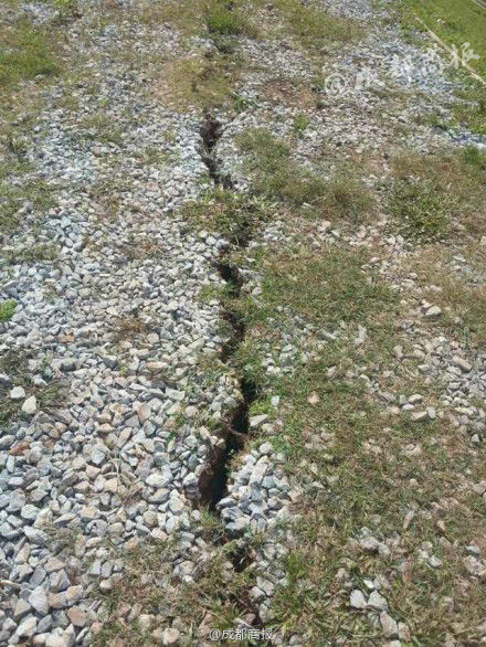
A crack was discovered in the Changhai Dam following Tuesday’s earthquake.
Although the 10 or so hydropower dams within a 200 km radius of Pu’er City are reportedly unharmed, a news update on October 8 revealed a 5-8 cm crack [pictured right] in the Changhai Dam in Yongping Town, the worst-hit region and location of the epicenter, following the seismic event. Another news report states that the governor of Yunnan has called for “emergency measures” to safeguard the Changhai Dam, some 10 kilometers upstream of Yongping.
Further Reading
Impoundment of two mega-dams on China’s Jinsha River triggers earthquake in Ludian
Yunnan earthquake linked to dam-building, says Chinese geologist
Impoundment of Jinping-I Dam on Yangtze tributary triggers quakes
On alert: RIS risk amid rash of earthquakes in China’s Sichuan-Yunnan region
Deadly earthquake in China may be aftershock of 2008 Wenchuan quake
Analysis of 5.1M earthquake in Badong County, Hubei, December 16, 2013
Categories: China's Dams, Dams and Earthquakes, Earthquake, RIS, Three Gorges Probe


Could The Three Gorges Dam turn out to be China’s Chernobyl , the harbinger of collapse of communist China?