
(May 19, 2009) Another landslide that took place at the Three Gorges, China on May 18 prompted me to write this post and look closer at the causes of slope instability in that area.

A new landslide occurred on the northern bank of Wuxia Gorge in Chongqing Municipality on Monday, May 18, 2009. The landslide sent 20,000 cubic meters of mountain mass into the Yangtze River. Photo by Chongqing Times.What is the Three Gorges?The Three Gorges Dam in China is the largest hydropower project in the world. The dam site is located near Maoping town, Zigui County, Hubei Province. The main body of the dam, which is 181 m high and 2,310 m long, was finished by the end of 2006, and the reservoir level will reach a maximum of 175 m in 2009, allowing for full electric power capacity.

From Wang et al. (2008).
Fourniadis et al. (2007) used a published 1:200,000 geological map as reference to visually interpret and identify the major lithological types and their geological structure settings in the study area. Lithological formations were grouped according to landslide susceptibility and classified into three stability-related broad categories: (a) limestone (massive limestone and dolomite); (b) sandstone (inter bedded sandstone/shale/marl);and (c) mudstone (mudstone, Quaternary sand and gravel).
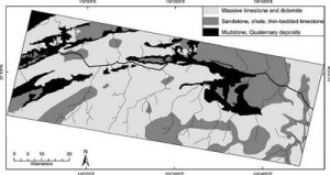
From Fourniadis et al. (2007).
Fourniadis et al. (2007) showed that “while steep mountain slopes in limestone are more susceptible to rockfalls, valley slopes formed in sandstone and shale sequences appear to be more susceptible to block slides. Also, shallow debris slides are likely caused by the presence of soft lithologies, such as mudstone and Quaternary deposits, and by the high level of dissection density as a result of road construction and urban development.”
Examples. Qianjiangping landslide.

A view of the Qianjiangping landslide (This photo is taken by Zhang, July 15, 2003). Wang et al. (2004) suggested that “the high water level in Qinggan-he River caused by the impoundment of the reservoir was the trigger of the landslide.”
Shuping landslide.

Photo of the Shuping landslide. From Wang et al. (2008).
The Shuping landslide was reactivated due to the impoundment of the Three Gorges Dam Reservoir in 2003. Based on the monitoring data, it was found that “movement of the Shuping landslide corresponded to water level change in the Three Gorges Reservoir. Movement of the landslide occurred during the wet season when the reservoir level is lowered for flooding control.”
References:
Fa-Wu Wang, Ye-Ming Zhang, Zhi-Tao Huo, Tatsunori Matsumoto, Bo-Lin Huang. “The July 14, 2003 Qianjiangping landslide,Three Gorges Reservoir, China.” Landslides (2004) 1:157–162.
I. G. Fourniadis, J. G. Liu, P. J. Mason. “Regional assessment of landslide impact in the Three Gorges area, China, using ASTER data: Wushan-Zigui.” Landslides (2007) 4:267–278.
Fawu Wang, Yeming Zhang, Zhitao Huo, Xuanming Peng, Kiminori Araiba, Gonghui Wang. “Movement of the Shuping landslide in the first four years after the initial impoundment of the Three Gorges Dam Reservoir, China.” Landslides (2008) 5:321–329.
Read this original article in Landslides Under Microscope Blog [PDF]

Categories: Dams and Landslides


Thank you for another informative web site. The place else may just I get that type of information written in such an ideal method?
I have a undertaking that I am just now running on, and I’ve been on the glance out for such information.